John Crump House Architectural Report, Block 17 Building 3B Lot 57Originally entitled: "Architectural Report the Red Lion Block 17, Building 3B Lot 57"
Colonial Williamsburg Foundation Library Research Report Series - 1336
Colonial Williamsburg Foundation Library
Williamsburg, Virginia
1990
ARCHITECTURAL REPORT
THE RED LION
Block 17, Building 3B, Lot 57
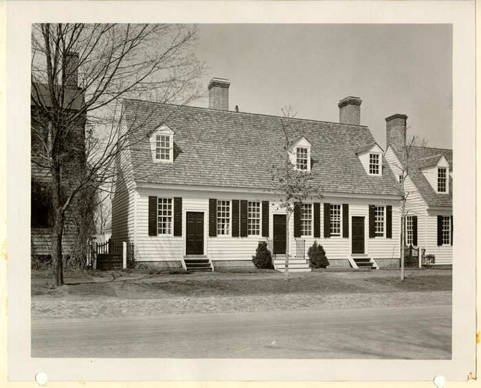
Illustration 1
Frontispiece
RED LION
After Restoration, 1941-1942
RED LION
Block 17, Building 3B, Lot 57
SUMMARY of INFORMATION SOURCES, graphic and descriptive, relating to Red Lion Tavern, Duke of Gloucester Street, Williamsburg, Virginia.
LOCATION
The exact location of "The Red Lion" as discussed in this report and as restored within the Colonial Area is shown on the map of Williamsburg (illustration 3).* This is on the northerly side of the Duke of Gloucester Street, in Block 17, Area 3B.
LOT AS SITE OF ORDINARY
York County Records, Book III, Deeds and Bonds, p. 1. Lot 58 was granted by the feoffees of the City of Williamsburg to Francis
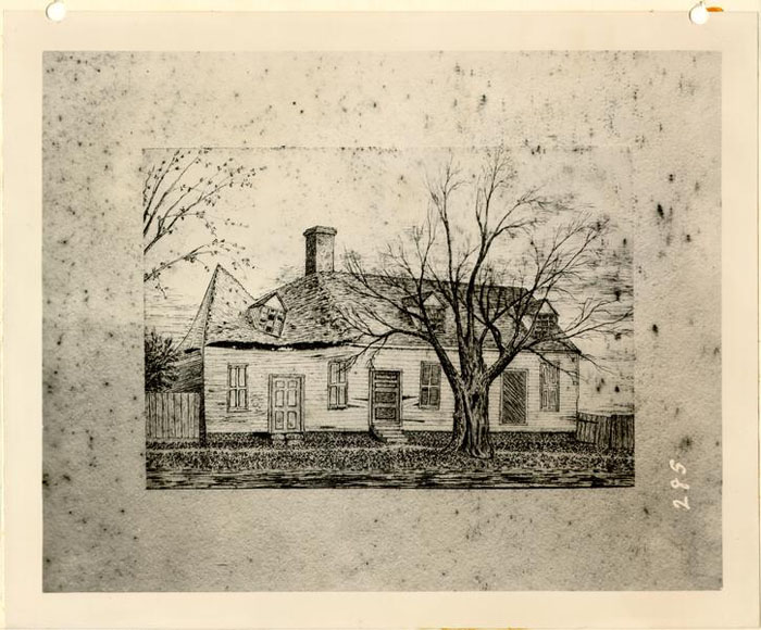 Illustration 3
Plan of Williamsburg
Lots 56, 57, 58 indicated site of RED LION on Colonial Lot 57 is in red.
The purpose of this map is to indicate location of building at a glance. It is proposed to have such a map on opening page of all architectural reports.
4
Sharpe, May 15, 1713. Sharpe was an "ordinary keeper" who "received an ordinary license, May 19, 1718 and again a renewed license September 21, 1719.*
A definite if faint glimpse of the physical appearance of a building on Colonial lot 57 before mid-18th century is given by a sketch drawing, prepared by Jos. Davenport, Surveyor of the City of Williamsburg, made in "obedience to an order of York County Court" dated May 16, 1743 in a dispute between Seth Seekright, lessee of Thomas Penman, Plaintiff, and John Burdett, Defendant, over the precise boundary line between lots 57 and 58.
Davenport's sketch of a house on lot 57 shows a building a story and a half high with a center doorway and window in each side; one window, toward the east end, appears wider than the window at the west end and suggests a shop window or large window to admit more than the usual amount of light. There are three dormers in the roof and a chimney at each end. The building on lot 57 is less long and of lesser architectural importance than the building on Burdett's lot (58) adjoining. Both buildings were placed a substantial distance to the left of the center of the respective lots. 1768 - Walter Lenox advertises his wig shop as follows:
"March 24, 1768. Walter Lenox, Perukemaker, Begs leave to inform the Public in General, and his Customers in Particular, that he has moved to the house known by the name of the Red Lion, next door above Mr Rind's Printing Office, where he carries on his business ...."#5.
- Frenchman's Map, C. 1782-86, shows a long building on the site, with two outbuildings.
- Rochambeau Map, 1782. Map of Williamsburg, believed to be a copy of Benjamin Bucktrout's map of 1803* shows the name Crump on lot 57, the name Greenhow on lot 56, and the name Meade on lot 58.
- Insurance Map, 1802, Policy No. 585. John Crump and Easter Whitfield, joint owners of lot 57, jointly insured the property with Mutual Assurance Society. Description of property in Policy No. 585:
"A Dwelling house 40 by 27 feet, one story high, built of wood and cov'd. with wood." #
It has not been completely established that this is a description of the property known as "Red Lion Inn."
1815 - Robert Anderson revalued the buildings which had [?] been previously valued in policy #585. This appeared on Insurance Policy No. 1387 and described "a dwelling of wood, one story high and covered with wood, 48 x 26 feet," occupied at east end by George Bray; and by Edward Tingle in the smaller, west end of property. Note on insurance plan: 3 outbuildings, consisting of one brick kitchen, one kitchen of wood and a chicken house.
- Recollections of Mr. John S. Charles, long a resident of Williamsburg, Principal of Matthew Whaley School for nearly twenty years. His typed transcript of "Recollections" is dated February, 1933, but prepared several years previously. They include glimpses of Williamsburg as early as 1860. Recalling the Red Lion, he says: 6.
MAIN STREET
PORCH
"A" dwelling of wood - one story high, covered with wood 48'x 26'
Occupied by George Bray occupied by Edward Teagle
S W E N [directionals arranged with "S" being at 12:00; "W" at 3:00; "N" at 6:00 and "E" at 9:00]
The above dwelling marked "A" is within 30 feet of three wooden buildings and one Brick Building covered with wood.
Brick Kitchen covered with wood. Wood Kitchen covered with wood. Chicken House.
BACK STREET
Valuation: $1700.00
1815/
[Insurance policy No. 1387, p. 8]
Copied for shapes. See Photostat of original, Dept. of Research and Records.On the site now occupied by the new dwelling owned by Mr. Bryhn, and the house next to the Cogbill house, there stood, up to a few years ago, a long one-story-and-a-half frame building with dormer windows, and two doors opening on the street. The uptown door was the entrance to the part used as a dwelling, and the downtown door was the entrance to the store once kept there. This house was the original "Red Lion," and not the little reddish brick house now at the N.W. corner of Duke of Gloucester and Colonial streets, which in recent years has been erroneously called the Red Lion.
This old Red Lion was evidently one of the originals, On account of its age it became dilapidated and a menacing fire trap so it was removed not many years ago.
7.Where the house of Mr. Donegan now stands, there stood, until after the War Between the States, a two-story frame house with porch on the western front, which was used as a residence; and in the eastern end there was a store for many years, which had the distinction of having been the only store here for a long period of the War.
The last house on the square facing on Duke of Gloucester street was upon the present site of Mrs. D. Armistead's residences, and was known as the Morrison house. This was a story-and-a-half frame house, with dormer windows. There was a porch along the street; but was high from the ground at the back. This old domicile was evidently also one of the originals, and being worn out in service, it was pulled down in 1883.*
Mrs. Victoria Lee in her recollections of Williamsburg (since 1861) speaks of the Red Lion as "a story-and-a-half house," ... "a few yards west of the Blassingham house." She continues:
The Red Lion was a rather long house, three doors opening on the street. This old house had a very interesting interior; I remember a hunting scene painted above the mantel in the west living room. Like so many other houses in Williamsburg, this house was occupied during the war by three families of refugees. The Red Lion was only a few feet east of the house in which I now live.**
These two memory accounts by Williamsburg citizens not only establish the location for the Red Lion in positive terms, but they both recall the continuance of the building, down to the end of the 19th century.
This old Red Lion, ... on account of its age ... was removed not many years ago. ***
The exterior appearance of this building that Mr. Charles speaks of as having been "removed not many years ago" was fortunately recorded graphically in a pen and ink sketch by an unknown amateur 8. artist (Photograph of drawing, #356, Coleman Collection, M. 8) and attributed, by its penciled notation "near 1900."
This sketch shows a fairly long building of frame and clapboarding; it is a story and a half in height, with three doorways and five windows. (See attached illustration.) There are three roof dormers and a chimney to the left of center of the building. The building appears in a ruinous condition, with sagged roof and left gable partly collapsed.
There are two points to be born in mind by the individuals who are interested in tracing the design history of the reconstructed Red Lion. The first is the location of the chimney -- "to the left of center of the building." This off-center location of chimney, it can be observed, suggests two periods of construction and two parts to the plan. These two parts are indicated clearly by the insurance drawings of 1815 when Robert Anderson revalued the building on lot 57. On the longer part (up to where the chimney occurs on the pen and ink drawing) the occupancy "by George Bray" is noted, while the smaller part was "occupied by Edward Teagle." As point two of our observation, there is evidence showing the existence of a porch for the Teagle house, also, as shown on the insurance map. This is indicated by the torn edge of the roof, without cornice boxing at the part where the porch is situated on the plan.
EVIDENCE OF ARCHAEOLOGY
- Archaeological Drawing: Block 17, Area "C", dated 6/17/31.
- Archaeological Report of H. S. Ragland, Block 17, Area "C" (Red Lion and Burdett Sites) 3/11/32. Copies are incorporated in Archaeological Report, "Red Lion Site," August, 1941.
9.- Supplementary Archaeological Report, Block 17, Area "C", east, west side of Colonial Lot 58. [Summer of 1941.]*
Most all foundation evidence was removed in course of various late construction incidents. There remained one wall with fireplace base, situated within about two feet-eight inches from Lee House. The foundation was interpreted to be old, possibly of the early 18th century. The dimension from north to south coincided approximately with the building on this plot, shown on lot 57 Insurance Policy #1387 which was given as 26'-0" in depth. 24'-10½" on Arch. Drwgs. but with other Colonial brickwork 1' more.
Here was evidence of archaeology -- an old wall with a chimney. On the other hand, there existed a pen drawing of Red Lion before its destruction around 1900. These two evidences of a building were studied and combined. They appeared to be one and the same building. It is true that the distance between the Lee House and the building shown in the drawing was greater than the distance between the same Lee House and the old excavated foundation. This increase of distance could have been a natural departure from reality or liberty assumed by the amateur artist.
However, at this time when first schemes were being made and the project studied -the Architects Perry, Shaw and Hepburn expressed the need for photographic data on which to base the design of the Inn. The existence of such a photograph was rumored and finally located. On June 16, 1932 William Perry wrote to Mr. Kenneth Chorley: 10.
Miss Annie Galt is in possession of a photograph of the old Red Lion Inn. . . . We understand, indirectly, that it will not be made available to us. Before proceeding with the plans of the Red Lion Inn ... we believe that it would be most advisable to see this photograph if possible. Is there any way ... etc."
Discussion of the missing and wanted photograph is further recorded in a note from Mr. Chorley to the Files, dated June 20, 1932. He said:
"... discussed with Mr. Perry on Saturday morning, his letter of June 16 concerning 'Filling in the Gaps -- Red Lion Inn. Block 17 ...' I and suggested to him that Mr. Shaw write to Miss Annie Galt direct, requesting the use of the photograph she has.
There was a gap of several years when the project for the restoration of Red Lion was again reviewed. This was in 1940, preceded by additional digging and examination at the west side of the adjoining lot 58 (summer of 1941).
The building restoration was based on the available evidence as previously related. No photograph of the Red Lion had been procurable. Work proceeded to the stage of "roofing the building." A chimney had been completed at the west end on the old colonial foundation and also the central chimney.
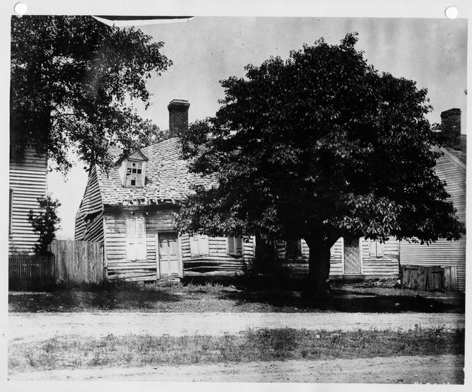
It was at this moment of "near completion" that the long-awaited and unexpected photograph of the "Old Red Lion" was given to Mr. Kendrew. With it there was a series of revelations which we will undertake to record by first describing the photograph.
Photograph ,#6524, called "Red Lion Inn." This was loaned to the Restoration by Miss Annie Galt Oct. 29-31, 1940, and who recalls the date of photograph as 1892.#
 Photograph
The building as restored was surprisingly similar to the Galt photograph, including the nature of windows, doors and dormers. There were, however, four dissimilarities. (1) The building of photograph was located -- not 2'-8" from the old Lee House, but an actual distance of nearly eight feet. (2) There was no chimney evident at the west end of the building, but only the chimney "slightly to the left of the building center," as previously discussed. (3) There was an additional window on the ground floor, making the result two windows on either side of the central doorway. (4) Then the dormers were differently place -- namely, dormers in approved reconstruction occur over end windows of south elevation, and over third window from the east end of building."**
RED LION
Block 17, Colonial Lot 57
- 1717 -
- Francis Sharpe obtained title to lots 57 and 58. This was a renewal of title, first granted in 1713. The title of 1717 must have been confirmed by erection of building on each lot, for Sharpe was able to bequeath both lots to his sons.*
- 1718 -
- Sharpe obtained license to operate an ordinary on either lot 57 or lot 58.
- 1719 -
- Sharpe died. He bequeathed lot 58 to his son, Jacob. Jacob Sharpe sold lot to Thomas Pattison -- before 1742. Lot 47 was bequeathed to his son John.
- 1742 -
-
- John Sharpe, son of Francis, was a planter in Surry County. As owner of lot 57 and house, he rented his property to Thomas Penman, a carpenter, for seven years.
- -Mention of Billyard house.
- -Mention of "convenient kitchen, 16 feet by 12 feet, with a brick chimney."
- -The owner, [John Sharpe] is "to pull down a back shed .... adjoining to the Mansion House on said lot, and rebuild it 2 feet wider."
- -Owner "to pale in the said lot and put the said house in tenantable order by next March."
- - Owner "... to build a smoke house 8 feet square."##
- 13.
- 1742 -
- John Sharpe sold lot 57 to Henry Wetherburn,, "tavern keeper," October 1, 1742.#
- 1743 -
- Lawsuit, Seekright vs. Burdett,, recorded in York County Records.** This record gives evidence oft (1) Location of lot lines; (2) Sketch drawings of the two ordinaries on property, on lot 57 -- an ordinary presumably Red Lion,; on lot 58 -- Burdett's ordinary.
- 1749 -
- Penman, still in possession of lot 57, according to deed to lot 56. This deed describes the eastern boundary of lot 56 as "the lot of Henry Wetherburn now in possession of Thomas Penman."
- Absence of records regarding lot 57 until end of century.
- 1766 -
- Nov. 6, first mention of name "Red Lion," without clue to location.***
- 1768 -
- March 24, "Walter Lenox, Perukemaker .... has moved to the house known by the name of the Red Lion, next door above Mr Rinds Printing Office."# The precise location of Mr. Rinds Printing Office has been conjectured to be Ludwell-Paradise House, based on the circumstance that Rind is reported to have lived at Ludwell-Paradise House from 1770 to 1773.##
CHRONOLOGY
So far as historical proof or contemporary records known to us are concerned, there exists today, no evidence to indicate that the house on lot 57 was named Red Lion during the 18th century.*
- 1782-86 -
- Frenchman's Map shows a building and a small kitchen on lot 57. No architectural characteristics.
- 1800 -
- The several maps of the City of Williamsburg, approximately 1800 indicate ownership of lot 57 as in the name of Crump, 58, in the name of Meade, and lot 56 in the name of Greenhow.
- 1802 -
- Insurance Policy No. 585, Mutual Insurance Society, shows that J. W. Dixon owned property east of lot 57.
- 1808 -
- Dividing-line-fence built between lot 57 and lot 58.
- 1808 -
- Account of Union Tavern relates to building on lot 57. Record Report, Addenda 6:17:32, assumes that Union Tavern was the former "Red Lion."
- 1815-20 -
- Esther Whitfield's estate taxed for 1/3 of lot 57; Edward Teagle, 1/3; Helen Maxwell, his wife, 1/3.
- 1820 -
- All parcels of lot 57, listed as one lot in tax records.
- 1820 -
- "Tax history of lots not clear." **
- C. 1860-1900
-
- "Western Part," says Mr. Charles, was "frame, with porch after the War Between the States, used as residence."
- - "Eastern End ... a store for many years ... distinction of having been only store here for a long period of the war." House of Mr. Donegan (ownership in name of Bryhn) on site 15 after around 1900.
- 1861 -
- Building known as Red Lion on lot 57 used as home for refugee families during the War-between-the--States, according to recollections of Mrs. Lee.
- 1900 -
- Before the end of the century the old house, described by Mr. Charles as "the original 'Red Lion' ... became dilapidated ... and it was removed not many years ago."
NOTE
A clear distinction should be made between records on the one hand, and remains on the other. Records are documents of a period that convey actual facts; while remains are inanimate vestiges of human life, otherwise termed building. Among the records, for use in determining when a building was built or occupied, in Colonial Williamsburg, must be included court accounts, deeds, wills, conveyances, inventories, and similar documents. Tax lists, maps and charts, charters, corporation records, statutes such as were devised in the Colony regulating building, are all of value in arriving at dates and nature of building. Finally, private records, such as diaries, letters, commercial papers have their place as historical evidence.
Remains, on the other hand, include houses themselves, altered, added to, moved from one site to another, parts removed and otherwise changed. These remains -- to be best understood -- should be studied in connection with records. Such study can make possible the discovery of characteristics that become altered from decade to decade and that serve in approximately dating a house or a cornice or other feature of building.
A.L.K.
THE RED LION
PLAN TYPE
In rebuilding the structure that we know as "Red Lion Inn", often mentioned in Virginia Gazette Advertisements, there were two alternatives to guide the architects of Colonial Williamsburg in reconstruction procedure; the one was "a sketch drawing" of a building on lot 57, prepared by Joseph Davenport. Surveyor of the City of Williamsburg at the time of the Seth Seekright and Thomas Penman law suit, May 16, 1743. This drawing is less in size than the dimensions of a postage stamp, and not sufficiently detailed to clearly determine its external appearance. The other alternative was the building that stood on the site, down to the late nineteenth century and recalled with a fair degree of correctness by Mr. John S. Charles and Mrs. Victoria Lee. These recollections were of a building on lot 57 known as Red Lion Inn. Further and most helpful assistance in revealing with some precision the frontal and end appearance of the building was served by a pen and ink building sketch made shortly before 1900 and the clear photograph of around 1890 in the possession of Miss Annie Galt.
The house plan, as reconstructed, was the result of a period of growth and enlargement and it presumably does not include the mid-eighteenth century building as drawn by Joseph Davenport. Surveyor of the City of Williamsburg in 1743. This building appears to have vanished, excepting for a few foundation fragments shown on archaeological drawings, block 17, area C, which may be examined by the student, and wherein the actual colonial wail footings are indicated and described.
17.The house plan reveals its enlargement from a small to a long structure. The three doorways suggest a triple house arrangement, which was in accordance with Mrs. Victoria Lee's mention of the house with "three doors opening on the street" and that it was "occupied during the war between the states by three families of refugees." There is a hallway at the center which gave entrance to a room at the west, and to rooms toward the east end. Mr. Lee refers to the "west living room", remembered as having "a hunting scene painted above the mantel". No description aids in the reconstruction of the plan toward the right, although a two room arrangement can be recognized unmistakably by the position of the doorways and chimney location. The plan was adjusted to the requirements of present day living with bath, kitchen, and washroom facilities.
The plan measurements are as follows: length 48'- 0"; the depth of the house is 26'-2½". The basement wall as rebuilt is a 13" wall.
ROOF TYPE.
The roof form is exceptional, having a steep slope at the front face (approximately fifty degrees) and a lesser slope of forty degrees at the rear side of the house. The eccentricity of slope is accounted for as follows:
In the course of its history, the house was enlarged by increasing the depth from north to south. The increase in depth was approximately six feet. Not wishing to place a flat roof over this 6' addition, the alternative was to change the rear slope (lessening the degree of steepness from fifty to forty) so that the single sweep of roof toward the rear would extend as far as the 6' addition and without lowering the roof edge below the roof edge at the front. It 18. is suggested that this design characteristic and the consideration of other features of the exterior be followed by an examination of the working drawings in the files of the Department of Architecture.
The roof covering is of shingles processed of asbestos cement and of this composition are proof against fire. This fire safe shingle was developed so as to meet the local fire ordinance requirements with specific ruling against wood shingles. These processed shingles resemble wood in texture, color and size and are laid 5½ inches to the weather. They have round butts and are of random widths in this respect following the shingle of the pre-Revolutionary period. The flashing between chimney and roof is of lead-coated copper. Other sheathing at edge of dormers and in dormer valleys is concealed and also of copper.
Gutters and downspouting were omitted as not common in adoption in Williamsburg. There is evidence for brick gutters at the base of buildings as a means for collecting water that falls from the roof edge and to eliminate washing of surface of earth. This gutter conducts the roof water away from the building and into drains.
EXTERIOR WALLS.
All exterior walls and interior partitions are framed with heart yellow pine with special features enumerated as follows: sills for wall framing are 4" x 6" with 4" x 6" corner posts, braced to sill; wall studs (2" x 4") are spaced sixteen inches on center in accordance with standard construction practice today; top of wall plates are 4" x 4"; joints at both floor levels are 2" x 8", braced where the clear span exceeds 8' x 0".
19.Weatherboarding is of heart cypress, with ¾" beaded edge and with a random exposure to the weather of 5 7/8" to 6½". Beaded corner boards, also of cypress serve as corner trim, following the eighteenth century detail for this feature with wider exposure at front than at ends of house.
Window frames, sills and sash are all reproductions of designs for sash as used in Williamsburg during the third quarter of the eighteenth century.
See Reference Files for an account of Window Design. Williamsburg; --. sash, frames, muntin bars, sills. This study is intended as a complete collection of window woodwork profiles, related, as far as possible, to date. Types of sills, frames, muntins, kinds of wood and wood finishes are discussed.
SHUTTERS.
The solid, three panel shutters are of cypress, and are replicas of the shutters that are shown on this building on the Annie Galt photograph on windows of the south elevation.
CORNICE. END BOARDS. FACIA BOARDS, etc.
The wood cornice, likewise of cypress; these wood trim details reproduce the profile and attachment methods, discovered in the case of other eighteenth century dwellings of the community. The common practice of carpenter and joiner of that time is followed.
MASONRY OF CHIMNEYS, FOUNDATION.
All brickwork for foundation walls above grade and all chimneys are built with face brick made at the "Restoration" brickyard and have the same size, color and glaze as a brick sample taken from the original foundation.
20.Since this building was reconstructed and was not a "restored old building," it was deemed desirable that all foundation work below grade be made as waterproof as possible. This meant the use of approved modern methods for basement construction of dense concrete for cellar floor and walls below the ground slope. (See Sheet 5R for work below grade).
Exposed brickwork for foundation is English bond, with mortar tooled with V marking which was customary for the late eighteenth century. Mortar color is off-white and slightly buff in color.
Hearth bricks are "rim of the kiln" brick, also from the "Restoration Kiln," the size of existing old hearth brick found elsewhere in Williamsburg. These are laid in a bed of mortar, with sand between the joints; their top surface is rubbed down to a true surface at the time of installation.
The chimney brickwork of shaft and the cap was shown on the Galt photograph and served as the guide to the chimney construction and finish.
Here, as elsewhere, in Colonial Williamsburg, chimney funnels were lined with terra cotta flue lining. This was done as an added precaution against fire. Cast iron dampers were installed within the chimney to facilitate the elimination of draft and closing the fireplace when not in use.
BASEMENT WINDOWS
Windows for ventilation and air in basement rooms are quite close to a standard in Colonial Williamsburg. They consist of a heavy solid frame of heart yellow pine or red cedar, mortised and joined with 21. ¾" wood pegs at the corners and having square or round horizontal rings as protecting bars. In some instances there was a horizontal rings as protecting bars. In some instances there was a center mullion, mortised to top and bottom members. This was done in the reproduction of atypical basement window in the Red Lion Inn as reconstructed. Glass in back of the window as described was exceptional. Here as in most instances of restored houses, an operating window sash was fitted into the frame on the interior side. This was done here and in present-day practice to retain basement warmth in winter.
The three dormers while irregularly spaced on the front (south) elevation are situated directly over the two end windows of the first floor, while the third dormer is centered over the ground floor window at the right of the center door. Here again, Williamsburg "practice" of the last quarter of the eighteenth century served as precedent for the dormer design. The Blow House at Martin's Hundred (eighteenth century) was also precedent for such dormers. Characteristics of the typical (most common) Williamsburg dormer are: gable facing over a twelve light window; verge boards are tapered from a narrow width at top to a greater width at the bottom; sides of dormers are faced with (tongue and groved siding with the siding boards applied with edges parallel to the roof slope. Moulded trim. sills, method of joining the sides, sills and heads were the methods of the early craftsmen of the Virginia colony.
Footnotes
There is no proved evidence for the rumored location of the Red Lion Inn in the "little reddish brick house" - however, see review of records pertaining to location, west of Paradise House in "Addenda to Red Lion Inn Research Report," August 27, 1941. The reasons for locating Red Lion Inn at Lot 57 are substantial; (1) Based on statements of aged citizens of Williamsburg who recall its nineteenth-century location; (2) Advertisement of Walter Lenox, Perukemaker, March 24, 1768 in Virginia Gazette (Purdie and Dixon, Editors), that he had moved to the Red Lion "next door above Mr. Rind's Printing office." Rind's printing office is located with only approximate definiteness by a statement of William Rind in his Virginia Gazette (Rind, Editor) on May 16, 1766 -- 2 years previous, that his "New Printing office" was near the Capitol. (Research Report, Block 17, Bldg. 3B, Colonial Lot 57, Red Lion Inn. Aug. 1941, p. 1 of Addenda.)